
Maintaining the power grid is a perpetual effort. But lately we’ve begun getting some help from the sky. Using a helicopter, our highly-trained aviation crew is using sophisticated surveying technology to capture hyper-accurate terrain and precise measurements of our electric infrastructure.
How it works
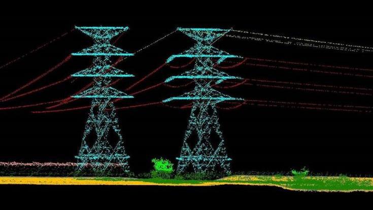
The technology, called LiDAR, which stands for Light Detection and Ranging, is a remote sensing method that uses light in the form of a pulsed laser to map physical features with very high resolutions. With this data, our engineers are generating infrastructure models to calculate the structural integrity of a power line. With this information, we can also predict how a power line changes over time with age. LiDAR data is also allowing us to evaluate how the terrain has changed, or how a power line that delivers a large amount of power can potentially impact service reliability.
To put it in perspective, a heavily loaded power line might begin to show signs of sagging, meaning it’s being weighed down. That happens when an increased level of energy is pulled from the power grid, like during new construction in the area or any other added electric demand to the grid. Having precise data using LiDAR during times like this can help us develop proactive improvement plans to aging infrastructure before a problem or outage occurs.
World impact of LiDAR
It wasn’t that long ago when LiDAR technology took centerstage, helping scholars reveal the ruins of a sprawling pre-Columbian civilization using aerial images of the now-unpopulated landscape. Records showed that the new discovery was far more complex and interconnected than most specialists had realized.
While we haven’t uncovered anything from the ancient era, once we have this data, we will evaluate system conditions and generate models to determine how structures change over the course of many years.
Working throughout the year
Capturing LiDAR data of our entire service territory that spans 4,100 miles will take some time. We are using helicopters to conduct this work and appreciate your patience as we fly over your community. Our goal is to give you peace of mind that we are investing in new, innovative technologies that will help to continue to provide you with clean, safe and reliable power now and in the future.
To learn more about LiDAR and how organizations like the National Oceanic and Atmospheric Administration (NOAA) is also using it, click here.